BRITICE
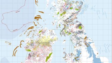
The BRITICE Glacial Mapping Project: version two release (2017) is a map and GIS database of glacial landforms related to the last British-Irish Ice Sheet. Maps and GIS data are freely downloadable, including an online GIS where you can zoom to your area of interest.

The British-Irish Ice Sheet
During the last 2.6 million years, a period of time known as the Quaternary, the climate has switched in and out of ice ages.
During these ice ages, kilometre-thick ice sheets covered large portions of the northern hemisphere, including Britain and Ireland.
The legacy of these ice sheets can be viewed in the landscape, as they left behind numerous landforms (geomorphology) that allows us to piece together the extent and geometry of the ice sheets.
Project aim
The aim of the BRITICE project is to bring together published information regarding the geomorphology (landforms) of the last British-Irish ice sheet.
The compiled record will help us better understand how ice sheets work. This is critical, as the ice sheets which currently exist in Greenland and Antarctica are losing mass at an accelerating rate. This ice ends up in the sea, raising global sea levels.
The record of a past ice sheet provided by BRITICE enables scientists to study how an ice sheet that disappeared in the past reacted to a changing climate.
We hope that the compilation will:
- showcase glacial geomorphology and the ice sheet to schools and the wider community
- stimulate greater scrutiny of published data
- facilitate use of field-evidence in numerical ice sheet modelling
- help direct field-workers in their future investigations
Interactive map
to zoom in on the landforms left behind by the last ice sheet in Britain and Ireland
Download the maps
Download the map of Ireland at higher resolution, 1:200,000 scale (PDF, 6.33MB)
Download the map of Mainland Britain at higher resolution, 1:200,000 scale (PDF, 11.6MB)Download the map of Northern Scotland at higher resolution, 1:200,000 scale (PDF, 3.65MB)
Teaching resources
Download "Glacial landforms: a teaching resource in maps and GIS" (PDF, 772KB)
Additional resources
Download the full BRITICE project bibliography (PDF, 478KB)
Compiling more than 100 years of research
The imprint of the last ice sheet on Britain and Ireland has been studied for over 100 years.
During this time, scientists conducting fieldwork and mapping from satellite data and aerial photography produced geomorphological (landform) maps, documenting the distribution of landforms left behind by the ice sheet.
We reviewed over 1,800 publications from the academic literature, British Geological Survey and Irish Geological Survey mapping. Relevant data from each published map were compiled into a geographic information system (GIS).
Version one of the BRITICE project was completed in 2004. Version two includes mapping updated from 2004. This revised database contains over 170,000 landforms. This is eight times the amount of information than was available in version one. The database now includes Ireland.
This increase has been facilitated by advances in technology, such as high-resolution digital elevation models of the land and seabed, as well as continued fieldwork. In some cases, this means that mapping of the same feature has been repeated.
Therefore, creation of a 'filtered database' required the removal of such instances. All data is retained for reference in the 'unfiltered database'.
The high density of data mean that sensibly sized maps which show all of the data are difficult to produce (they would have to be 5m by 5m in size).
In order to see the full detail of the mapping, you need to consult the filtered database, and the three pdf maps which are designed to be digitally viewed at a scale of 1:200,000.
We therefore created a 'generalised map' which shows a cartographically reduced representation of the data, suitable for printing at A0 size at a 1:1,250,000 scale.
What is included?
- Moraines
-
Accumulations of sediment with a topographic expression recording an ice margin position.
- Subglacial lineations
-
Streamlined landforms primarily composed of drift, formed at the sole of the ice sheet, orientated in the direction of ice flow. Includes drumlins and mega-scale glacial lineations.
- Subglacial ribs
-
Ridges formed at the base of the ice sheet, transverse to flow direction. Previously known as ribbed or Rogen moraine, the word moraine being misleading as they are known not to record ice marginal positions.
- Crag and tails
-
Bedrock hills (crags) with tapering sediment ridges (tails). The tails are usually formed in the lee of crags, extending in a down-ice direction.
- Glacially-streamlined bedrock
-
Includes roches moutonÃĐes, whalebacks, rock drumlins and mega-grooves.
- Erratics
-
Rocks or clasts of a different type than the surrounding native bedrock, presumed to have been transported by the flow of ice.
- Trough mouth fans
-
Glacially-fed fan or delta-like accumulations of sediment occurring at mouths of glacial troughs at the continental shelf edge.
- Meltwater channels
-
Channels cut by glacial meltwater. Includes lateral, marginal, proglacial and subglacial channels, as well as tunnel valleys.
- Eskers
-
Elongate ridges of glaciofluvial sediment deposited in subglacial meltwater pipes.
- Cirques
-
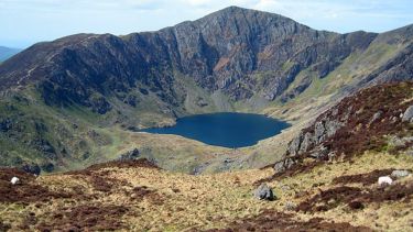
Glacially-eroded armchair-shaped hollows incised into mountains. Also known as corries or cwms.
- Ice-dammed lakes
-
The extent of proglacial lakes inferred from a combination of lake deposit distribution and topography.
Future updates
The census date for this version of the map was 2015, and so anything published after this time is not included. However, it is inevitable that some information may be missing, and we hope to update the map periodically.
Other mapping may have been included in the 'unfiltered' database, but excluded from the final map due to repeat mapping.
If you have any extra information, criticisms or suggested amendments, contact Chris Clark who will ensure they are considered for the next update.


